ASU Learning Sparks
The sky view factor, SVF for short, is a measure of how much sky is visible at a given location, measured on an imaginary upper hemisphere centered at that location. Envision standing in the center of a huge glass dome. The ratio of the sky to non-sky area projected onto the dome is the sky view factor. It is a dimensionless number between 0 and 1 - 0 meaning you cannot see the sky at all, and 1 means you are in the middle of nowhere in Montana with a big sky and no horizon limitation.
The sky view factor is an important concept in urban climatology because it is a 2-dimensional description of the surrounding urban form at a location. Urban morphology, meaning the physical 3-dimensional form of cities, is a significant driver of urban climate. It impacts air temperature, air flow, ventilation, turbulence, solar radiation, land surface temperature, and even air quality in the urban canopy layer. Scientists do not always have 3D city models available, so they can use the sky view factor as an approximation.
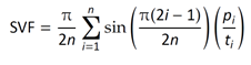
The sky view factor for a specific location can be calculated from fisheye photographs [FIG 1] that show the upper hemisphere projected onto a 2-dimensional plane -- the image. To calculate the amount of visible sky in the hemispherical view, researchers must first identify sky pixels in the photograph, which can either be determined based on the sky color or through advanced image segmentation techniques such as deep learning. The segmented fisheye photo is then divided into a predefined number of annular rings of equal width, and the sky view factor is calculated by summing up the sky contributions in each ring. If n is the number of rings, i is the ring index, pi is the number of sky pixels in a ring with index i, and ti is the total number of pixels, the sky view factor is calculated as follows:
Sky view factor footprints, or the histogram of the sky view factor distribution in cities, have recently been calculated from Google Street View images and mapped for various urban areas around the world. Those sky view factor maps are important because they help researchers assess the urban heat island and longwave radiative heat loss at night. Studies have shown that neighborhoods with low sky view factors experience higher pedestrian-level air temperatures at night, because the longwave radiation is trapped in the urban canopy layer. The sky view factor is also one of the major variables in radiation models that calculate mean radiant temperature, a synthetic parameter that summarizes the direct and reflected short and longwave radiation fluxes a human body is exposed to. Mean radiant temperature is an important driver of outdoor thermal comfort in hot and dry cities.